
TOP 10 ROAD TRIPS FROM GIRONA, SPAIN: The Young Traveler's Essential Field Guide to Costa Brava & Beyond
- Pavł Polø
- Feb 20
- 12 min read

Introduction: Girona Is Your Base Camp — Use It
Let's be straight with you: Girona doesn't get the hype it deserves. Barcelona grabs the headlines, but the locals know that this walled Roman city sitting at the confluence of four rivers is one of the most strategically placed driving hubs in all of Europe. From Girona, you are literally 30 minutes from the Costa Brava road trips that will ruin you for mediocre scenery forever.
But here's what nobody tells the first-timer:
Pain Point #1: Most travelers treat Girona as a day trip from Barcelona — and miss out on weeks of world-class driving.
Pain Point #2: The roads inland (the Garrotxa volcanic zone, the Pyrenean foothills) are just as dramatic as the coast — often better.
Pain Point #3: Navigation apps route you on highways. The real magic is on the C-, GI-, and N-series roads, most of which aren't in travel blogs.
Pain Point #4: Drone fliers get burned hard by Spanish regulations in national parks — read the drone section before you pack your DJI.
This guide covers the 10 best drives radiating out of Girona — distances, road types, elevation gain, cycling potential, photography hotspots, wildlife, flora, and the kind of place you can genuinely impress a woman. All verified against current route data and Spanish tourism sources. 10 ROAD TRIPS FROM GIRONA, SPAIN provide a guide and something to plan and look forward to.
Looking for Music for self-development, going through life, traveling, and enjoying life. 🇵🇱 — Muzyka na samorozwój, jak osoba idzie przez życie, podróże, i jak osoba docenia życie. Listen to Pavł Polø on Spotify.

10 ROAD TRIPS FROM GIRONA, SPAIN
1. The Costa Brava Coastal Loop — Girona to Begur to Cadaqués
Distance: ~160 km round trip | Road Type: GI-682 coastal road — narrow, twisting tarmac | Elevation Change: 0–350m, constant rollers
This is the flagship Costa Brava road trip. You drop southeast from Girona on the C-66 before picking up the GI-682 — a coastal cliff road that makes the Amalfi look wide. The road threads medieval fishing hamlets: Pals (stone towers, unchanged since the 13th century), Begur (castle hilltop views to the open Mediterranean), Tamariu (a cove so turquoise it looks fake), and finally Cadaqués — the whitewashed surrealist village that drove Dalí to stay for life.
Vista Points: Cap de Creus peninsula gives you the most easterly point in mainland Spain — a bare, windswept promontory where the Tramontane wind scours the rocks clean. Golden hour here is insane.
For a date, walk Cadaqués at dusk and eat at a harbor restaurant. That's it. No notes needed.
Road Cycling: The GI-682 is a legitimate cycling route but the narrow lanes and tourist traffic in summer (June–August) make it best attempted March–May or September–October. Strava segments exist for every climb.
Flora & Fauna: Maritime scrubland (garriga) dominates — wild rosemary, cistus, and Aleppo pine. Sea cliffs host Audouin's gull, a rare Mediterranean species. Bottlenose dolphins are common offshore from Cap de Creus.
Photography: Tamariu cove from the GI-682 overlook above the beach. Cap de Creus lighthouse at sunrise. Cadaqués church and harbor at golden hour.
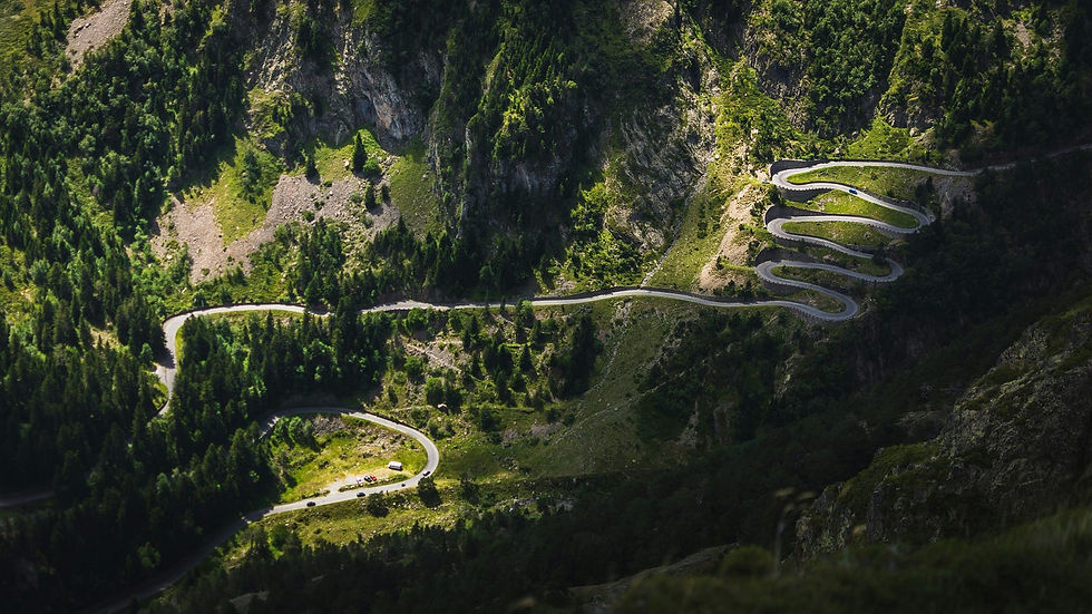
2. Garrotxa Volcanic Zone — Girona to Olot via Sant Feliu de Pallerols
Distance: ~80 km | Road Type: C-63 and GI-524, smooth mountain roads | Elevation Change: Girona (70m) to Olot (443m), climbing through volcanic landscape
The Garrotxa Volcanic Zone is the most geologically active area in the Iberian Peninsula and one of the most underrated drives in all of Spain. You ascend from the coastal plain into a landscape of perfect conical volcanoes draped in ancient beech and oak forest. There are 40 extinct volcanoes and 20 lava flows in this natural park.
Stop at Santa Pau — a perfectly preserved medieval village inside a volcanic caldera. The town square (Plaça Major) is genuinely one of the most beautiful small squares in Catalonia. Another world.
Vista Points: Mirador del Croscat gives you a cross-section view of the Croscat volcano — Europe's youngest at roughly 11,000 years old. The Fageda d'en Jordà is a beech forest growing on an ancient lava flow — totally flat, which is bizarre given the surrounding hills.
Flora & Fauna: The Garrotxa is home to wild boar, roe deer, genets, and the Eurasian otter along the Fluvià river. Botanic interest is significant: the beech forests are at their southern climatic limit, creating a microclimate cooler than surrounding areas.
Road Cycling: Excellent. The GI-524 from Sant Feliu to Olot is a popular climb with manageable gradients. Quiet roads, forest shade.
Photography: The Fageda d'en Jordà in autumn (late October) when the beeches turn. Santa Pau's arched medieval square. Volcanic crater rim at Croscat.
For a date: Stay at a rural masia (farmhouse hotel) in the park and eat volcanic zone black beans (fesols de Santa Pau) — a Catalan PDO product unique to this soil.
3. Pyrenean Foothills — Girona to Camprodon to Núria
Distance: ~140 km | Road Type: C-26 and GI-401, mountain switchbacks | Elevation
Change: Girona (70m) to Camprodon (950m) to Núria (1,964m by rack railway)
Head north and the landscape transforms fast. The C-26 takes you through the Ripollès comarca — forested ridgelines, Romanesque churches in every village, and the air gets cooler by the kilometer. Camprodon is a river-straddling Pyrenean town with a 12th-century Romanesque bridge so photogenic it's almost unfair.
From Ribes de Freser, the Cremallera rack railway climbs to the Vall de Núria — a glacial cirque at nearly 2,000 meters. No road access to Núria exists; the train is the only way in. That isolation has kept it extraordinary.
Vista Points: The Núria cirque from the sanctuary terrace. The GI-401 switchbacks above Queralbs looking back down the valley.
Flora & Fauna: Alpine meadows above the treeline support Pyrenean chamois (isard), marmots, and golden eagles. Pyrenean brook salamander lives in cold streams. Subalpine fir and Scots pine dominate the upper forest zones.
Road Cycling: The climb to Camprodon from Sant Joan de les Abadesses is a legit cycling challenge. Gradients up to 8%. Quiet roads with serious views.
Photography: Camprodon's Pont Nou bridge from river level. Núria cirque reflected in the reservoir. Any of the Romanesque church towers in Ripollès villages.
4. The Empordà Plains & Medieval Villages — Girona to Peralada to El Port de la Selva
Distance: ~100 km | Road Type: C-252 and GI-602, flat agricultural roads transitioning to coast | Elevation Change: Minimal until the Serra de Rodes climb (670m)
The Alt Empordà is wide, wind-swept agricultural plain behind the northern Costa Brava — a landscape of vineyards, olive groves, and castle towns that Salvador Dalí claimed as his emotional homeland. The Tramontane wind blows hard here (100+ days per year) and it shapes everything: the landscape, the cuisine, the architecture.
Stop at Peralada for its castle-winery complex, then push to the Serra de Rodes — a dramatic ridge road that climbs to the ruined monastery of Sant Pere de Rodes (10th century), sitting 670m above the sea with panoramic views to France and the open Mediterranean. It's one of the best road drives in all of Catalonia.
Flora & Fauna: Empordà salt marshes (Aiguamolls) host flamingos, spoonbills, and over 300 bird species during migration. The garrigue scrubland on the Serra de Rodes supports Egyptian mongoose, the only Spanish mainland population.
Photography: Sant Pere de Rodes monastery against the sea. Aiguamolls wetlands at dawn during bird migration (September–November).
For a date: Peralada's castle wine bar. Order Cava made on-site and watch the sun hit the battlements.
5. Around the Estany de Banyoles — Short Lake Circuit
Distance: ~50 km circuit | Road Type: GI-524 and local roads, flat and fast | Elevation Change: Negligible — lake sits at 172m
Quick one this, but don't dismiss it. Banyoles is the largest natural lake in Catalonia — a karst lake of extraordinary clarity. It hosted the 1992 Barcelona Olympics rowing events. The drive around the lake and through the compact medieval core of Banyoles is a half-day affair that pairs well with a longer trip into the Garrotxa.
The lakeside restaurants serve grilled freshwater fish (carp, pike-perch) in a way that feels distinctly Central European, not Mediterranean — because the ecosystem genuinely is different.
Flora & Fauna: The lake supports unique endemic crustaceans, large pike, and great crested grebe. Kingfishers are common. Otter presence has been confirmed in recent years.
Road Cycling: The flat circuit around the lake is a genuine cycling classic. Closed for a prestigious cycling race each spring. Fully paved, no traffic.
Photography: Dawn mist over the lake from the east shore. The porticoed medieval arcades of Banyoles old town.
6. The Wild Gavarres — Girona into the Forest Massif
Distance: ~70 km loop | Road Type: GI-681 and forest tracks, some unpaved sections | Elevation Change: Girona (70m) to Gavarres peaks (~535m)
The Gavarres is a forested hill massif sitting between Girona and the coast that most tourists completely skip. That's a gift for you. Holm oak and cork oak woodland cover these ridges — the cork harvest is still active, and peeled trunks show the brilliant burnt-red bark beneath. The interior villages (Monells, Cruïlles, Madremanya) are some of the least-visited and most beautiful medieval settlements in Catalonia.
Monells, in particular, has an arcaded square that feels untouched since the 14th century. No tourist infrastructure. No gift shops. Just the square, the church, and an old man reading a newspaper.
Flora & Fauna: This is prime wild boar territory. Genets, stone martens, and roe deer are common. The cork oak woodland is a critical habitat for lesser kestrel and short-toed snake eagle.
Photography: Monells square at midday when the stone arches cast hard shadow geometry. Cork oak trunks in late summer post-harvest — abstract, textural, extraordinary.
7. Ter River Valley — Girona to Torroella de Montgrí
Distance: ~60 km | Road Type: C-66 and local roads, easy driving | Elevation Change: Minimal — river valley floor
The Ter flows from the Pyrenees through Girona and empties near the coastal town of Torroella de Montgrí, dominated by a bare limestone mountain (the Montgrí Massif, 303m) that rises abruptly from flat agricultural land. The drive follows the river through a mosaic of rice paddies, wetlands, and orchards that feel more like the Po Valley than coastal Spain.
Torroella is a working Catalan market town — not a tourist construct — with a superb Friday market and an intact 14th-century palace. From here, the road continues to L'Estartit and the Medes Islands marine reserve, the best diving in the western Mediterranean.
Flora & Fauna: The Ter delta wetlands hold herons, egrets, marsh harriers, and during migration, thousands of waders. River otters have returned to the lower Ter in recent years — a genuine conservation success story.
Photography: The Montgrí massif from the rice paddies at sunrise. Torroella market day crowd.
8. Alt Empordà Wine Route — Figueres to Espolla to Garriguella
Distance: ~80 km | Road Type: GI-602 and rural wine routes, narrow between vine rows | Elevation Change: 0–400m, rolling hills
The Empordà DO wine region produces wines that are as interesting as any in Spain — driven by the Tramontane wind, which concentrates sugars and intensifies the Grenache and Carignan grapes that dominate here. This drive takes you through the vine-covered foothills of the Alberes mountains, which form the border with France.
Stop at Espolla and Garriguella — tiny wine villages where the co-operative wineries sell directly at cellar prices. You'll also pass Cistella, a near-abandoned hilltop village being slowly resettled by artists and organic farmers.
Flora & Fauna: The Alberes are a critical wildlife corridor between France and Spain — lynx-watch efforts are active here. Wild boar, roe deer, and recently confirmed wolf passage in the wider Pyrenean corridor.
Photography: Vine rows with the Alberes ridge behind them. Cistella's crumbling church against a sky full of Tramontane clouds.
For a date: A tasting at any small-production Empordà winery followed by anchovies from L'Escala (30 minutes away) — the best anchovies in the world, not an exaggeration.
9. Pre-Pyrenean Circuit — Girona to Besalú to Castellfollit de la Roca
Distance: ~90 km | Road Type: C-66 and N-260, well-maintained with river crossings | Elevation Change: Girona (70m) to Castellfollit (350m)
Besalú is one of those towns that earns its entry in every European medieval village ranking — a fortified Romanesque bridge with toll towers over the Fluvià river, a Jewish quarter with a rare intact mikveh (ritual bath), and a compact old town that takes about 90 minutes to explore properly. It's 37 km from Girona. There is literally no excuse not to go.
Castellfollit de la Roca takes things up a notch — a village of 1,000 people built on a basalt lava cliff 50 meters above the river confluence. The main street runs along the literal edge of the cliff. Houses overhang the drop. It is, objectively, insane urban planning and absolutely worth the detour.
Flora & Fauna: River corridor along the Fluvià supports kingfisher, grey heron, and Eurasian dipper. White storks nest on the church towers of several Empordà villages — visible May–August.
Photography: Besalú bridge from the riverbank below. Castellfollit's cliff-edge village profile from the road south — one of the most dramatic village silhouettes in Europe.

10. Into France — Girona to Collioure via the Portbou Pass
Distance: ~130 km to Collioure | Road Type: N-IIa coast road and AP-7 (toll), then D914 in France | Elevation Change: Sea level to 250m at the border pass
Cross-border drives from Girona are criminally underused. The N-IIa hugs the Costa Brava all the way to Portbou — a Spanish border town of faded elegance where Walter Benjamin famously ended his flight from the Nazis. From there, 10 minutes into France and you're in Collioure: a French fishing village of painted anchovy boats, a pink-towered château, and Matisse's palette. He painted here 40 times in a single summer.
The D914 coastal road on the French side (Côte Vermeille) rivals anything on the Spanish coast and is almost entirely unknown to English-speaking travelers.
Flora & Fauna: Alberes mountain scrub transitions to French garrigue — similar species profile (cistus, lavender, wild thyme) but the landscape feels less managed. Peregrine falcons nest on sea cliffs at Cap Cerbère.
Photography: Collioure harbor with the château behind. The border pass above Portbou looking back into Spain.
For a date: Dinner in Collioure at any harbor-front restaurant. Catalan cuisine with a French wine selection. You look well-traveled. She's impressed.

Drone Video & Photography: What You Need to Know Before You Fly in Spain
Spain has tightened its drone regulations significantly under Royal Decree 517/2024, which harmonizes Spanish law with EU Regulation 2019/947. The rules are serious and the fines are real. Here's the actual situation:
National Parks & Protected Areas: You cannot fly in national parks, natural parks, Biosphere Reserves, or wildlife conservation areas without specific written authorization from the park administration or AESA (Spain's aviation authority). The Garrotxa Volcanic Zone and Cap de Creus fall under this. Apply through AESA at drones.aesa@seguridadaerea.es.
Registration: Any drone 250g+ or with a camera must be registered with AESA as an operator. Registration valid for one year, renewable.
Altitude Limit: 120 meters AGL maximum in Open category across all of Spain.
Urban Areas: Drones 250g+ require advance notification to Spain's Ministry of Interior before flying over towns or cities — file at least 5 days in advance.
No-Fly Zones: Check the ENAIRE Drones app (official, Spanish-only) or the ENAIRE website for current UAS geographical zones before every flight. Do not rely on DJI's built-in geo-fencing; it is not always current with Spanish rules.
Military Restricted Zones (ZRVF): Photography-restricted zones require separate approval from the Spanish Ministry of Defense.
Sub-250g Drones (e.g., DJI Mini series): More permissive rules apply — no training certificate required for category A1 — but registration is still required if the drone has a camera. Urban notification rules still apply.
Bottom line: Check the ENAIRE Drones map at enaire.es before every flight. For protected areas, email the park authority and AESA well in advance. The fine for unauthorized flight in a national park can reach €225,000 under Spanish law.
5 Gold Nuggets: What This Drive Series Actually Teaches You
Gold Nugget #1 — The Interior > The Coast in Summer. From June to August, the Costa Brava coastal roads are genuinely difficult: narrow, tourist-choked, and hot. The Garrotxa, the Gavarres, and the Pyrenean drives are empty, cooler by 8–10°C, and twice as interesting. Go inland in summer.
Gold Nugget #2 — Medieval Villages Off the GI-Roads. Catalonia has preserved its medieval heritage better than anywhere in Spain precisely because it was less economically developed. The villages along these routes — Santa Pau, Monells, Cruïlles, Besalú — are the real deal. Learn three words of Catalan (gràcies, bon dia, per favor) and doors open.
Gold Nugget #3 — The Tramontane Wind is a Navigator. When the Tramontane blows from the northwest (which it does constantly in the Alt Empordà), the sky scrubs clean and the visibility extends to the Pyrenees and the Balearics simultaneously. Plan your Cape Creus and Serra de Rodes drives for Tramontane days.
Gold Nugget #4 — The Best Road Cycling in Europe Costs Nothing. Girona has become the global training base for professional road cyclists (Team Visma-Lease a Bike, EF Education, and others all base here) precisely because the road network is exceptional. Rent a bike for €40/day from any of the 10+ cycling shops in the city center and you're on pro-circuit roads within 5 minutes of leaving the old town.
Gold Nugget #5 — Eat Local or Don't Eat. Every region on these routes has a PDO or hyper-local product that is demonstrably better than anything you can get elsewhere: fesols de Santa Pau black beans (Garrotxa), anchovies of L'Escala (Costa Brava), Empordà wines, and Cadaqués' sea urchins (when in season, winter). If the menu has pizza, leave.
References & Clickable Links
Official Tourism & Navigation
Drone Regulations
Road Cycling
Scientific & Academic
Folch, R., et al. (2004). The Garrotxa Volcanic Zone: geological and ecological values. Institut d'Estudis Catalans, Barcelona. [Regional monograph on volcanic zone ecology and conservation]
Blondel, J. & Aronson, J. (1999). Biology and Wildlife of the Mediterranean Region. Oxford University Press. ISBN 978-0198500148. [Definitive reference for Mediterranean flora, fauna & ecology]
Contact for Drone Permits
AESA drone queries: drones.aesa@seguridadaerea.es | Tel: +34 91 396 80 00
All route information verified against current Spanish road maps and official tourism sources. Drone regulations current as of Royal Decree 517/2024. Always check ENAIRE before flying.


Comments